Geolocate

Melgar topographic map

Click on the map to display elevation.

About this map
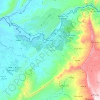
Name: Melgar topographic map, elevation, terrain.

Location: Melgar, Oriente, Tolima, 734001, Colombia (4.09569 -74.75214 4.27261 -74.55537)

Average elevation: 2,110 ft

Minimum elevation: 876 ft

Maximum elevation: 6,070 ft

Other topographic maps

Click on a map to view its topography, its elevation and its terrain.

Alto De Letras

Colombia > Tolima

Average elevation: 4,957 ft

Parque Mitológico

Colombia > Tolima > Espinal

Average elevation: 1,066 ft

Toche

Colombia > Tolima

Average elevation: 7,733 ft

Gear up for your next adventure:

🍳Camping Cook Set - Complete cookware for outdoor meals
🧥Men's Rain Shells - Premium waterproof and breathable jackets for mountain weather
🩹Survival Bandages - High‑quality bandages for emergencies
🔭Stargazing Telescopes - Perfect for camping in low-light pollution areas shown on maps
🌡️Handheld Weather Meters - Measure wind, temp, and pressure for safe mountain travel

As an Amazon Associate, this site earns from qualifying purchases at no extra cost to you.