
Make a donation
Gear up for your next adventure:
As an Amazon Associate, this site earns from qualifying purchases at no extra cost to you.
Privas topographic map
Click on the map to display elevation.
Make a donation
Gear up for your next adventure:
As an Amazon Associate, this site earns from qualifying purchases at no extra cost to you.
Privas
During the siege of 1629, the town of Privas was well defended by walls and ditches. Privas also has gorges to its south, east and north that provide a natural defence. Given this topography, the Huguenots in the town did not believe that a strong attack from the east was possible. Nevertheless, on 22 May, the Swiss mercenaries of the attacking Royalist Catholic army of Cardinal Richelieu managed to haul by hand six huge pieces of artillery, each weighing about four tons, from Tauléac across the Ouvèze river and up the zig-zag path onto the plateau of Le Vanel, to the east of the town walls. From this decisive vantage point they bombarded the town until its surviving defenders were forced to evacuate and take their last stand on Mont Toulon on its west. During the siege, five hundred Royalist attackers and one thousand Protestant defenders were killed. Surviving defenders were executed, imprisoned, or deported to be galley slaves. By fire or cannon, the majority of the buildings in the town were destroyed. Privas was a ghost town for many years after. It is estimated that as a result of the defeat of the Huguenots in the region, one-fifth of the Protestant population of the Ardèche emigrated. After the defeat of the Camisard revolt (1702–1715) a further 50,000 Archèche Protestants left France. Many fled to England or Switzerland.
Make a donation
Gear up for your next adventure:
As an Amazon Associate, this site earns from qualifying purchases at no extra cost to you.
About this map
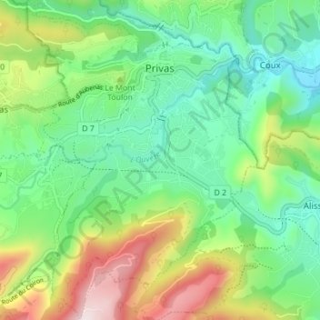
Name: Privas topographic map, elevation, terrain.
Average elevation: 1,204 ft
Minimum elevation: 571 ft
Maximum elevation: 2,503 ft
Make a donation
Gear up for your next adventure:
As an Amazon Associate, this site earns from qualifying purchases at no extra cost to you.
Other topographic maps
Click on a map to view its topography, its elevation and its terrain.
Make a donation
Gear up for your next adventure:
As an Amazon Associate, this site earns from qualifying purchases at no extra cost to you.
Hameau de Romanieux
France > Auvergne-Rhône-Alpes > Ardèche > Saint-Alban-d'Ay
Average elevation: 2,329 ft
Make a donation
Gear up for your next adventure:
As an Amazon Associate, this site earns from qualifying purchases at no extra cost to you.
Make a donation
Gear up for your next adventure:
As an Amazon Associate, this site earns from qualifying purchases at no extra cost to you.
Les Riailles
France > Auvergne-Rhône-Alpes > Ardèche > Dunière-sur-Eyrieux
Average elevation: 1,430 ft
Make a donation
Gear up for your next adventure:
As an Amazon Associate, this site earns from qualifying purchases at no extra cost to you.
Saint-Pierre-la-Roche
France > Auvergne-Rhône-Alpes > Ardèche > Saint-Pierre-la-Roche > Saint-Pierre-la-Roche
Average elevation: 1,512 ft
Make a donation
Gear up for your next adventure:
As an Amazon Associate, this site earns from qualifying purchases at no extra cost to you.