Geolocate

Hergatz topographic map

Click on the map to display elevation.

About this map

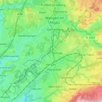
Name: Hergatz topographic map, elevation, terrain.

Location: Hergatz, Landkreis Lindau, Bavaria, Germany (47.63886 9.79342 47.67862 9.92441)

Average elevation: 2,021 ft

Minimum elevation: 1,667 ft

Maximum elevation: 2,667 ft

Other topographic maps

Click on a map to view its topography, its elevation and its terrain.

Oberreutin

Germany > Bavaria > Landkreis Lindau > Lindau (Bodensee)

Average elevation: 1,421 ft

Staudach

Germany > Bavaria > Landkreis Lindau

Average elevation: 2,005 ft

Buflingsried

Germany > Bavaria > Landkreis Lindau > Scheidegg

Average elevation: 2,490 ft

Holzleute

Germany > Bavaria > Landkreis Lindau > Stiefenhofen

Average elevation: 2,651 ft

Hagers

Germany > Bavaria > Landkreis Lindau > Hergensweiler

Average elevation: 1,706 ft

Gear up for your next adventure:

🎒Waterproof Dry Bags - Keep your electronics and maps dry inside your pack
🛠️Outdoor Gear Repair Kit - Essential tools to fix gear on the trail
😴Insulated Sleeping Pads - Compact and warm pads for high-elevation camping
🍳Camping Cook Set - Complete cookware for outdoor meals
🪶Fire Starter Kit - Reliable fire starter for survival and camping

As an Amazon Associate, this site earns from qualifying purchases at no extra cost to you.