
Paca topographic map
Interactive map
Click on the map to display elevation.
About this map
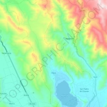
Name: Paca topographic map, elevation, terrain.
Location: Paca, Provincia de Jauja, Junín, Perú (-11.74351 -75.56817 -11.63462 -75.49710)
Average elevation: 12,165 ft
Minimum elevation: 11,014 ft
Maximum elevation: 14,757 ft
Other topographic maps
Click on a map to view its topography, its elevation and its terrain.
Laguna de Paca
Laguna de Paca, Paca, Jauja, Junín, Perú
Average elevation: 11,220 ft