
Vaals topographic map
Interactive map
Click on the map to display elevation.
About this map
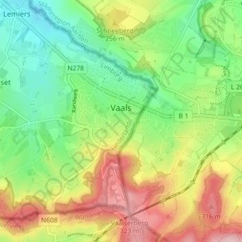
Name: Vaals topographic map, elevation, terrain.
Location: Vaals, Limburg, Nederland (50.75276 5.96561 50.78499 6.02785)
Average elevation: 732 ft
Minimum elevation: 476 ft
Maximum elevation: 1,089 ft
Other topographic maps
Click on a map to view its topography, its elevation and its terrain.
Hoogste Punt van Nederland
Hoogste Punt van Nederland, Vaals, Limburg, Nederland, 6291 BX, Nederland
Average elevation: 892 ft