
Mattoon topographic map
Interactive map
Click on the map to display elevation.
About this map
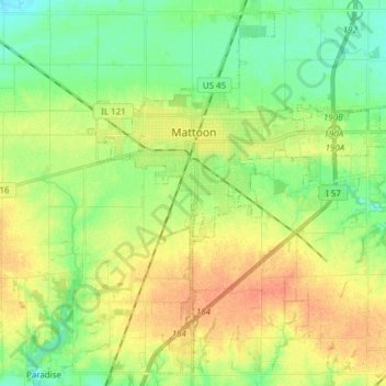
Name: Mattoon topographic map, elevation, terrain.
Location: Mattoon, Coles County, Illinois, 61938, United States (39.41045 -88.41922 39.52085 -88.26652)
Average elevation: 722 ft
Minimum elevation: 659 ft
Maximum elevation: 794 ft
One of the main factors determining the settlement of Mattoon and Coles County in general was the topography. Coles County straddled a timberline in the southern half and prairie in the north. The forested areas were primarily fed by two major rivers: the Embarras River in the east and the Kaskaskia in the west. The prairie, known as the "Grand Prairie", was generally wet and swampy. An early historian described the geography:
Other topographic maps
Click on a map to view its topography, its elevation and its terrain.
Fox Ridge State Park
United States > Illinois > Coles County
Fox Ridge State Park, Coles County, Illinois, United States
Average elevation: 656 ft
Charleston
United States > Illinois > Coles County
Charleston, Coles County, Illinois, 61920, United States
Average elevation: 673 ft
Lerna
United States > Illinois > Coles County
Lerna, Coles County, Illinois, United States
Average elevation: 748 ft