
Engwegen topographic map
Interactive map
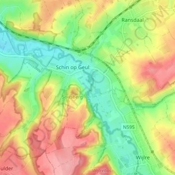
Click on the map to display elevation.
About this map
Name: Engwegen topographic map, elevation, terrain.
Average elevation: 394 ft
Minimum elevation: 226 ft
Maximum elevation: 571 ft
Other topographic maps
Click on a map to view its topography, its elevation and its terrain.
Oud-Valkenburg
Nederland > Limburg > Schin op Geul
Oud-Valkenburg, Schin op Geul, Valkenburg aan de Geul, Limburg, Nederland, 6305 AB, Nederland
Average elevation: 384 ft
Schoonbron
Nederland > Limburg > Schin op Geul
Schoonbron, Schin op Geul, Valkenburg aan de Geul, Limburg, Nederland, 6305 PR, Nederland
Average elevation: 397 ft