Geolocate

Panabo topographic map

Click on the map to display elevation.

About this map

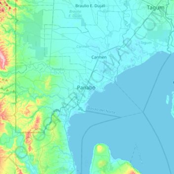
Name: Panabo topographic map, elevation, terrain.

Location: Panabo, Davao del Norte, Davao Region, 8105, Philippines (7.14519 125.52457 7.46519 125.84457)

Average elevation: 98 ft

Minimum elevation: -3 ft

Maximum elevation: 1,027 ft

Gear up for your next adventure:

🎁Geography Themed Gifts - Unique gift ideas for map lovers and geography enthusiasts
👓Polarized Sunglasses - Outdoor sunglasses for glare reduction
🏫Relief Map Kits - Hands-on tools for teaching landforms and elevation
🚑Emergency Bivvies - Heat-reflective sleeping bags for survival situations
📡Handheld GPS Device - Reliable handheld GPS for outdoor navigation

As an Amazon Associate, this site earns from qualifying purchases at no extra cost to you.