
Make a donation
Gear up for your next adventure:
As an Amazon Associate, this site earns from qualifying purchases at no extra cost to you.
Zona Central topographic map
Click on the map to display elevation.
Make a donation
Gear up for your next adventure:
As an Amazon Associate, this site earns from qualifying purchases at no extra cost to you.
Zona Central
The topography of central Chile includes a coastal range of mountains running parallel to the Andes. Lying between the two mountain ranges is the so-called Central Valley, which contains some of the richest agricultural land in the country, especially in its northern portion. The area just north and south of Santiago is a large producer of fruits, including the grapes from which the best Chilean wines are made. Exports of fresh fruit began to rise dramatically in the mid-1970s because Chilean growers had the advantage of being able to reach markets in the Northern Hemisphere during that part of the world's winter. Most of these exports, such as grapes, apples, and peaches, go by refrigerator ships, but some, such as berries, go by air freight.
Make a donation
Gear up for your next adventure:
As an Amazon Associate, this site earns from qualifying purchases at no extra cost to you.
About this map
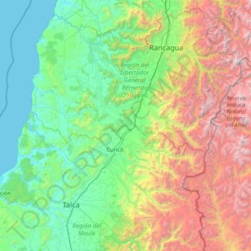
Name: Zona Central topographic map, elevation, terrain.
Average elevation: 3,678 ft
Minimum elevation: 0 ft
Maximum elevation: 16,755 ft
Make a donation
Gear up for your next adventure:
As an Amazon Associate, this site earns from qualifying purchases at no extra cost to you.