
Crozon-sur-Vauvre topographic map
Interactive map
Click on the map to display elevation.
About this map
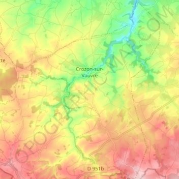
Name: Crozon-sur-Vauvre topographic map, elevation, terrain.
Average elevation: 1,142 ft
Minimum elevation: 784 ft
Maximum elevation: 1,506 ft
Other topographic maps
Click on a map to view its topography, its elevation and its terrain.
Valençay
France > Centre-Val de Loire > Indre
Valençay, Châteauroux, Indre, Centre-Val de Loire, Metropolitan France, 36600, France
Average elevation: 430 ft
Langé
France > Centre-Val de Loire > Indre
Langé, Châteauroux, Indre, Centre-Val de Loire, Metropolitan France, 36600, France
Average elevation: 469 ft
Gournay
France > Centre-Val de Loire > Indre
Gournay, La Châtre, Indre, Centre-Val de Loire, Metropolitan France, 36230, France
Average elevation: 676 ft
Champ de Crozon
France > Centre-Val de Loire > Indre > Crozon-sur-Vauvre
Champ de Crozon, Bévet, Crozon-sur-Vauvre, La Châtre, Indre, Centre-Val de Loire, Metropolitan France, 36140, France
Average elevation: 1,043 ft
Les Illions
France > Centre-Val de Loire > Indre > Buzançais > Saint-Étienne
Les Illions, Saint-Étienne, Buzançais, Châteauroux, Indre, Centre-Val de Loire, Metropolitan France, 36500, France
Average elevation: 384 ft
Buzançais
France > Centre-Val de Loire > Indre
Buzançais, Châteauroux, Indre, Centre-Val de Loire, Metropolitan France, 36500, France
Average elevation: 427 ft
Briantes
France > Centre-Val de Loire > Indre
Briantes, La Châtre, Indre, Centre-Val de Loire, Metropolitan France, 36400, France
Average elevation: 823 ft
Saint-Plantaire
France > Centre-Val de Loire > Indre
Saint-Plantaire, La Châtre, Indre, Centre-Val de Loire, Metropolitan France, 36190, France
Average elevation: 968 ft
La Broue
France > Centre-Val de Loire > Indre > Cuzion
La Broue, Cuzion, Châteauroux, Indre, Centre-Val de Loire, Metropolitan France, 36190, France
Average elevation: 853 ft
Champarnoux
France > Centre-Val de Loire > Indre > Saint-Plantaire
Champarnoux, Saint-Plantaire, La Châtre, Indre, Centre-Val de Loire, Metropolitan France, 36190, France
Average elevation: 869 ft
Éguzon-Chantôme
France > Centre-Val de Loire > Indre
Éguzon-Chantôme, Châteauroux, Indre, Centre-Val de Loire, Metropolitan France, 36270, France
Average elevation: 866 ft
Le Blanc
France > Centre-Val de Loire > Indre
Le Blanc, Indre, Centre-Val de Loire, Metropolitan France, 36300, France
Average elevation: 364 ft
Concremiers
France > Centre-Val de Loire > Indre
Concremiers, Le Blanc, Indre, Centre-Val de Loire, Metropolitan France, 36300, France
Average elevation: 367 ft
Montlevicq
France > Centre-Val de Loire > Indre > Montlevicq
Montlevicq, La Châtre, Indre, Centre-Val de Loire, Metropolitan France, 36400, France
Average elevation: 755 ft
Lacs
France > Centre-Val de Loire > Indre
Lacs, La Châtre, Indre, Centre-Val de Loire, Metropolitan France, 36400, France
Average elevation: 735 ft
La Morijo
France > Centre-Val de Loire > Indre > Cuzion > La Jarrige
La Morijo, La Jarrige, Cuzion, Châteauroux, Indre, Centre-Val de Loire, Metropolitan France, 36190, France
Average elevation: 741 ft
Fontgombault
France > Centre-Val de Loire > Indre
Fontgombault, Le Blanc, Indre, Centre-Val de Loire, Metropolitan France, 36220, France
Average elevation: 367 ft
Saint-Gaultier
France > Centre-Val de Loire > Indre
Saint-Gaultier, Le Blanc, Indre, Centre-Val de Loire, Metropolitan France, 36800, France
Average elevation: 440 ft
Châteauroux
France > Centre-Val de Loire > Indre > Châteauroux
Châteauroux, Indre, Centre-Val de Loire, Metropolitan France, 36000, France
Average elevation: 502 ft