
Düdinghausen topographic map
Interactive map
Click on the map to display elevation.
About this map
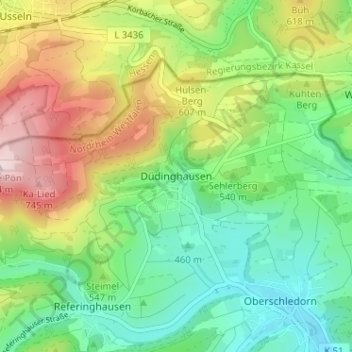
Name: Düdinghausen topographic map, elevation, terrain.
Average elevation: 1,772 ft
Minimum elevation: 1,325 ft
Maximum elevation: 2,546 ft
Other topographic maps
Click on a map to view its topography, its elevation and its terrain.
Rothenberg
Deutschland > Nordrhein-Westfalen > Hochsauerlandkreis > Medebach
Rothenberg, Medebach, Hochsauerlandkreis, Nordrhein-Westfalen, 59964, Deutschland
Average elevation: 1,749 ft
Referinghausen
Deutschland > Nordrhein-Westfalen > Hochsauerlandkreis > Medebach
Referinghausen, Medebach, Hochsauerlandkreis, Nordrhein-Westfalen, 59964, Deutschland
Average elevation: 1,745 ft
Dreislar
Deutschland > Nordrhein-Westfalen > Hochsauerlandkreis > Medebach > Dreislar
Dreislar, Medebach, Hochsauerlandkreis, Nordrhein-Westfalen, Deutschland
Average elevation: 1,378 ft