
Make a donation
Gear up for your next adventure:
As an Amazon Associate, this site earns from qualifying purchases at no extra cost to you.
Mooresville topographic map
Click on the map to display elevation.
Make a donation
Gear up for your next adventure:
As an Amazon Associate, this site earns from qualifying purchases at no extra cost to you.
About this map
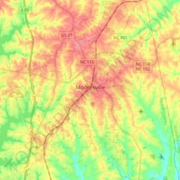
Name: Mooresville topographic map, elevation, terrain.
Average elevation: 827 ft
Minimum elevation: 682 ft
Maximum elevation: 955 ft
Iredell County trails, hiking, mountain biking, running and outdoor activities
Make a donation
Gear up for your next adventure:
As an Amazon Associate, this site earns from qualifying purchases at no extra cost to you.
Other topographic maps
Click on a map to view its topography, its elevation and its terrain.
Make a donation
Gear up for your next adventure:
As an Amazon Associate, this site earns from qualifying purchases at no extra cost to you.
Statesville
United States > North Carolina > Iredell County > Statesville > Statesville
Statesville has a humid subtropical climate (Cfa) like most of the state of North Carolina, although its higher elevation leads to cooler temperatures than much of the Piedmont. Summers are generally hot and humid, with mild nights, while winters are usually cool with chilly nights and sporadic snowfall.…
Average elevation: 873 ft
Make a donation
Gear up for your next adventure:
As an Amazon Associate, this site earns from qualifying purchases at no extra cost to you.