Geolocate

Province of Rioja topographic map

Click on the map to display elevation.

About this map

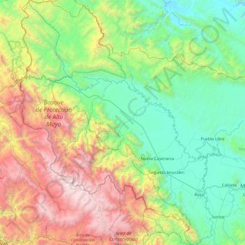
Name: Province of Rioja topographic map, elevation, terrain.

Location: Province of Rioja, San Martín, Peru (-6.23412 -77.77568 -5.40690 -77.11982)

Average elevation: 5,417 ft

Minimum elevation: 2,270 ft

Maximum elevation: 13,074 ft

Other topographic maps

Click on a map to view its topography, its elevation and its terrain.

Morro de Calzada

Peru > San Martín > Calzada > Calzada

Average elevation: 3,153 ft

Rey del Valle

Peru > San Martín > Alonso de Alvarado

Average elevation: 3,927 ft

Guantanamo

Peru > San Martín

Average elevation: 1,834 ft

San Andrés

Peru > San Martín > Jepelacio

Average elevation: 4,183 ft

La Unión

Peru > San Martín > La Banda de Shilcayo

Average elevation: 1,407 ft

Gear up for your next adventure:

🔌Solar Panel Charger - Charge gear sustainably outdoors
🛏️Cold Weather Sleeping Bag - Warm sleeping bag for cold conditions
🧭Pro Hiking Compasses - High-accuracy liquid-filled compasses for topographic orientation
🧭Hiking Compass - Precision compass for reliable navigation in the wilderness
🎒Outdoor Daypacks - Lightweight backpacks designed for carrying maps and essential gear

As an Amazon Associate, this site earns from qualifying purchases at no extra cost to you.