Geolocate

Hout Bay topographic map

Click on the map to display elevation.

About this map

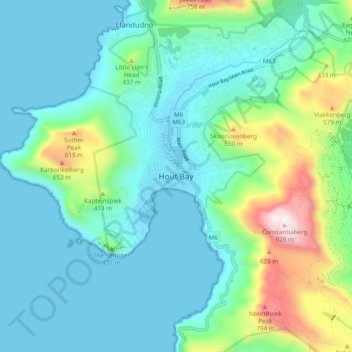
Name: Hout Bay topographic map, elevation, terrain.

Location: Hout Bay, City of Cape Town, 7872, South Africa (-34.08309 18.31565 -34.00309 18.39565)

Average elevation: 623 ft

Minimum elevation: 0 ft

Maximum elevation: 3,022 ft

Gear up for your next adventure:

🔋Rechargeable Batteries - Power up your outdoor devices
📦Gear Storage Bags - Organize and protect outdoor equipment
🪑Portable Camp Table - Compact table for campsite meals
🥤Water Filter Bottle - All‑in‑one filter bottle for safe hydration
🔥Fast-Boil Camping Stoves - Efficient cooking systems for quick trail meals

As an Amazon Associate, this site earns from qualifying purchases at no extra cost to you.