
Make a donation
Gear up for your next adventure:
As an Amazon Associate, this site earns from qualifying purchases at no extra cost to you.
La Candelaria topographic map
Click on the map to display elevation.
Make a donation
Gear up for your next adventure:
As an Amazon Associate, this site earns from qualifying purchases at no extra cost to you.
About this map
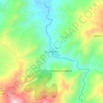
Name: La Candelaria topographic map, elevation, terrain.
Location: La Candelaria, Ricaurte, Boyacá, Colombia (5.50075 -73.62567 5.54075 -73.58567)
Average elevation: 7,723 ft
Minimum elevation: 7,028 ft
Maximum elevation: 8,852 ft
Make a donation
Gear up for your next adventure:
As an Amazon Associate, this site earns from qualifying purchases at no extra cost to you.
Other topographic maps
Click on a map to view its topography, its elevation and its terrain.
Gachantivá
Gachantivá is a town and municipality in the Ricaurte Province, part of the Colombian department of Boyacá. Gachantivá is located at altitudes ranging from 2,000 metres (6,600 ft) to 3,300 metres (10,800 ft) on the Altiplano Cundiboyacense and borders Villa de Leyva in the south, Santa Sofía in the west,…
Average elevation: 7,759 ft
Villa de Leyva
Located away from major trade routes in a high altitude valley of semi-desert terrain, and with no mineral deposits nearby to exploit, the town has undergone little development in the last 400 years. As a consequence, it is one of the few towns in Colombia to have preserved completely its original colonial…
Average elevation: 7,927 ft
Make a donation
Gear up for your next adventure:
As an Amazon Associate, this site earns from qualifying purchases at no extra cost to you.
Garagoa
Garagoa (Spanish pronunciation: [ɡaɾaˈɣoa]) is a town and municipality in Colombia, located in the Boyacá Department. It covers an area of 191.75 km2 and the urban centre is located at an altitude of 1,650 metres (5,410 ft) above sea level. Parts of the municipality reach altitudes of 3,050 metres (10,010…
Average elevation: 6,522 ft
Make a donation
Gear up for your next adventure:
As an Amazon Associate, this site earns from qualifying purchases at no extra cost to you.
Villa de Leyva
Located away from major trade routes in a high altitude valley of semi-desert terrain, and with no mineral deposits nearby to exploit, the town has undergone little development in the last 400 years. As a consequence, it is one of the few towns in Colombia to have preserved much of its original colonial style…
Average elevation: 7,927 ft
Make a donation
Gear up for your next adventure:
As an Amazon Associate, this site earns from qualifying purchases at no extra cost to you.
Parque Natural Regional Páramo de Rabanal
Colombia > Boyacá > Guachetá > Samacá
Average elevation: 10,075 ft
Make a donation
Gear up for your next adventure:
As an Amazon Associate, this site earns from qualifying purchases at no extra cost to you.
Rondón
Rondón is a town and municipality in the Márquez Province, part of Boyacá Department, Colombia. The urban centre of Rondón is situated at an altitude of 2,075 metres (6,808 ft) on the Altiplano Cundiboyacense in the Colombian Eastern Ranges of the Andes. It is 61 kilometres (38 mi) away from the…
Average elevation: 8,110 ft
Ráquira
Ráquira, is a municipality and town in Boyacá Department, Colombia, part of the subregion of the Ricaurte Province. Ráquira is situated on the Altiplano Cundiboyacense and the urban center at an altitude of 2,150 metres (7,050 ft). It borders Tinjacá and Sutamarchán in the north, Guachetá, Cundinamarca…
Average elevation: 8,783 ft
Duitama
Duitama (Spanish pronunciation: [dwiˈtama]) is a city and municipality in the department of Boyacá. It is the capital of the Tundama Province. Duitama is located 195 kilometres (121 mi) northeast of Bogotá, the capital city of Colombia and 50 kilometres (31 mi) northeast of Tunja, the capital Boyacá.…
Average elevation: 9,905 ft
Make a donation
Gear up for your next adventure:
As an Amazon Associate, this site earns from qualifying purchases at no extra cost to you.
Paipa
Paipa is located 15 km west of Duitama and 48 kilometres (30 mi) to the northeast of Tunja, the capital of the department, in the Cordillera Oriental (Eastern Ranges) of the Colombian Andes. It is the main tourist center of the region, with a number of large hotels and hot springs. At an elevation of 2525 m,…
Average elevation: 9,281 ft
Make a donation
Gear up for your next adventure:
As an Amazon Associate, this site earns from qualifying purchases at no extra cost to you.
Make a donation
Gear up for your next adventure:
As an Amazon Associate, this site earns from qualifying purchases at no extra cost to you.
Villa de Leyva
Located away from major trade routes in a high altitude valley of semi-desert terrain, and with no mineral deposits nearby to exploit, the town has undergone little development in the last 400 years. As a consequence, it is one of the few towns in Colombia to have preserved much of its original colonial style…
Average elevation: 7,927 ft
Make a donation
Gear up for your next adventure:
As an Amazon Associate, this site earns from qualifying purchases at no extra cost to you.