
Glen Ogle topographic map
Interactive map
Click on the map to display elevation.
About this map
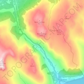
Name: Glen Ogle topographic map, elevation, terrain.
Average elevation: 1,519 ft
Minimum elevation: 305 ft
Maximum elevation: 2,648 ft
Other topographic maps
Click on a map to view its topography, its elevation and its terrain.
Loch Earn
United Kingdom > Scotland > Stirling > Lochearnhead
Loch Earn, Lochearnhead, Stirling, Scotland, United Kingdom
Average elevation: 1,289 ft
Lochearnhead
United Kingdom > Scotland > Stirling > Lochearnhead
Lochearnhead, Stirling, Scotland, FK19 8PR, United Kingdom
Average elevation: 899 ft