
Distrito Municipal de KaMubukwana topographic map
Interactive map
Click on the map to display elevation.
About this map
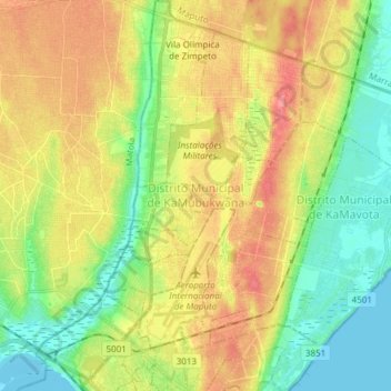
Name: Distrito Municipal de KaMubukwana topographic map, elevation, terrain.
Location: Distrito Municipal de KaMubukwana, Maputo, Mozambique (-25.94754 32.52109 -25.81171 32.62461)
Average elevation: 102 ft
Minimum elevation: -7 ft
Maximum elevation: 223 ft
Other topographic maps
Click on a map to view its topography, its elevation and its terrain.
Catembe
Catembe, Distrito Municipal de KaTembe, Maputo, 0106-03, Mozambique
Average elevation: 39 ft
Aeroporto "B"
Aeroporto "B", Distrito Municipal de Nlhamankulu, Maputo, 0102-02, Mozambique
Average elevation: 108 ft
Distrito Municipal de KaMpfumo
Distrito Municipal de KaMpfumo, Maputo, Mozambique
Average elevation: 85 ft