
Elatochori topographic map
Interactive map
Click on the map to display elevation.
About this map
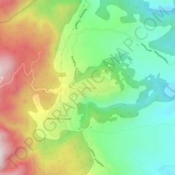
Name: Elatochori topographic map, elevation, terrain.
Average elevation: 2,369 ft
Minimum elevation: 1,339 ft
Maximum elevation: 3,911 ft
Elatochori is known for its ski center, which is located at an altitude of 1,400 to 1,800 meters (4,600 to 5,900 feet) on the southeastern slopes of the Pierian Mountains. At the base of the ski resort and at the location "Papá Choráfi", there is a dining room and a chalet with a total area of 450 sq.m. (4,840 sq.ft.) with a capacity of more than 400 people. It operated for the first time on a trial basis, in 2000, and officially in 2001. It is 8 km (5 miles) from the village and 36 km (22 miles) from the city of Katerini. The Ski Sports and Mountaineering Association operates in the Ski Center.
Other topographic maps
Click on a map to view its topography, its elevation and its terrain.
Dion - Olympos Municipality
Greece > Macedonia and Thrace > Pieria Regional Unit
Dion - Olympos Municipality, Pieria Regional Unit, Central Macedonia, Macedonia and Thrace, Greece
Average elevation: 2,064 ft