
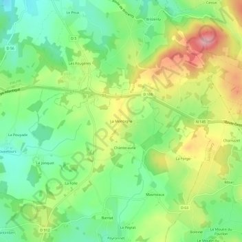
La Montagne topographic map
Interactive map
Click on the map to display elevation.
About this map
Name: La Montagne topographic map, elevation, terrain.
Average elevation: 1,424 ft
Minimum elevation: 1,207 ft
Maximum elevation: 1,739 ft
Other topographic maps
Click on a map to view its topography, its elevation and its terrain.
L'Age au Seigneur
France > Nouvelle-Aquitaine > Creuse > Le Grand-Bourg
L'Age au Seigneur, Le Grand-Bourg, Guéret, Creuse, Nouvelle-Aquitaine, France métropolitaine, 23240, France
Average elevation: 1,309 ft
Celles
France > Nouvelle-Aquitaine > Creuse > Le Grand-Bourg
Celles, Le Grand-Bourg, Guéret, Creuse, Nouvelle-Aquitaine, France métropolitaine, 23240, France
Average elevation: 1,289 ft
Huviers
France > Nouvelle-Aquitaine > Creuse > Le Grand-Bourg
Huviers, Le Grand-Bourg, Guéret, Creuse, Nouvelle-Aquitaine, France métropolitaine, 23240, France
Average elevation: 1,355 ft