
Thank you for supporting this site ❤️
Make a donation
Make a donation
Gear up for your next adventure:
As an Amazon Associate, this site earns from qualifying purchases at no extra cost to you.
Carvoeiro topographic map
Click on the map to display elevation.
Thank you for supporting this site ❤️
Make a donation
Make a donation
Gear up for your next adventure:
As an Amazon Associate, this site earns from qualifying purchases at no extra cost to you.
About this map
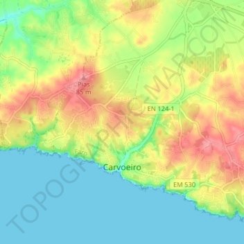
Name: Carvoeiro topographic map, elevation, terrain.
Location: Carvoeiro, Lagoa e Carvoeiro, Lagoa, Faro, Portugal (37.08533 -8.49404 37.12768 -8.42963)
Average elevation: 118 ft
Minimum elevation: -3 ft
Maximum elevation: 279 ft
Thank you for supporting this site ❤️
Make a donation
Make a donation
Gear up for your next adventure:
As an Amazon Associate, this site earns from qualifying purchases at no extra cost to you.