
Eucalyptus topographic map
Interactive map
Click on the map to display elevation.
About this map
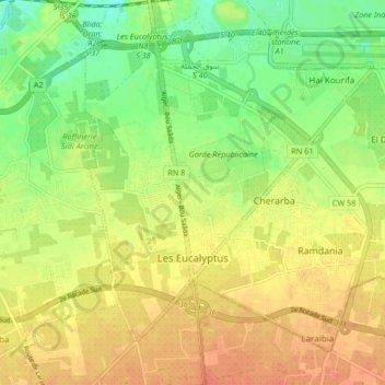
Name: Eucalyptus topographic map, elevation, terrain.
Location: Eucalyptus, Baraki District, Algiers, Algeria (36.64042 3.12398 36.69553 3.20697)
Average elevation: 79 ft
Minimum elevation: 7 ft
Maximum elevation: 138 ft
Other topographic maps
Click on a map to view its topography, its elevation and its terrain.
Baraki District
Algeria > Algiers > Baraki District
Baraki District, Algiers, Algeria
Average elevation: 131 ft