Geolocate

Baker topographic map

Click on the map to display elevation.

About this map

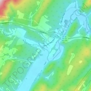
Name: Baker topographic map, elevation, terrain.

Location: Baker, Hardy County, West Virginia, United States (39.02177 -78.76474 39.06177 -78.72474)

Average elevation: 1,535 ft

Minimum elevation: 1,250 ft

Maximum elevation: 2,398 ft

Hardy County trails, hiking, mountain biking, running and outdoor activities

Other topographic maps

Click on a map to view its topography, its elevation and its terrain.

Lost River

United States > West Virginia > Hardy County > Mathias

Average elevation: 1,650 ft

Trout Pond

United States > West Virginia > Hardy County

Average elevation: 2,156 ft

Wardensville

United States > West Virginia > Hardy County

Average elevation: 1,076 ft

Wardensville

United States > West Virginia > Hardy County

Average elevation: 1,076 ft

Moorefield

United States > West Virginia > Hardy County

Average elevation: 856 ft

Lost River

United States > West Virginia > Hardy County > Mathias

Average elevation: 1,654 ft

Moorefield

United States > West Virginia > Hardy County

Average elevation: 856 ft

Gear up for your next adventure:

📡Handheld GPS Device - Reliable handheld GPS for outdoor navigation
🧢Outdoor Hiking Hat - Sun protection hat for outdoor explorers
🦶Hiking Gaiters - Keep debris and water out of your boots
🧺Microfiber Travel Towels - Compact and fast-drying towels for trail use
🌎3D Topographic Globes - Raised relief globes for a tactile understanding of geography

As an Amazon Associate, this site earns from qualifying purchases at no extra cost to you.