Geolocate

Aurach topographic map

Click on the map to display elevation.

About this map
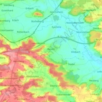
Name: Aurach topographic map, elevation, terrain.

Location: Aurach, Ansbach (district), Bavaria, 91589, Germany (49.20560 10.31525 49.27856 10.46819)

Average elevation: 1,503 ft

Minimum elevation: 1,371 ft

Maximum elevation: 1,742 ft

Other topographic maps

Click on a map to view its topography, its elevation and its terrain.

Eyerlohe

Germany > Bavaria > Ansbach (district)

Average elevation: 1,417 ft

Gear up for your next adventure:

🪶Camp Gear Gift Set - Perfect gift bundle for outdoor fans
👟Men's Trail Runners - Lightweight footwear for fast-paced exploration and light hiking
📱Solar Portable Charger - Solar power bank for charging devices off‑grid
🎒Outdoor Daypacks - Lightweight backpacks designed for carrying maps and essential gear
🛠️Outdoor Gear Repair Kit - Essential tools to fix gear on the trail

As an Amazon Associate, this site earns from qualifying purchases at no extra cost to you.