
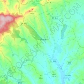
Ventosa topographic map
Interactive map
Click on the map to display elevation.
About this map
Name: Ventosa topographic map, elevation, terrain.
Location: Ventosa, Alenquer, Lisboa, Portugal (39.09766 -9.13387 39.14891 -9.05334)
Average elevation: 476 ft
Minimum elevation: 220 ft
Maximum elevation: 1,181 ft
Other topographic maps
Click on a map to view its topography, its elevation and its terrain.
Casais do Chorão
Portugal > Lisboa > Alenquer > Vila Verde dos Francos
Casais do Chorão, Vila Verde dos Francos, Alenquer, Lisboa, 2550-077, Portugal
Average elevation: 817 ft
Cabanas do Chão
Cabanas do Chão, Abrigada e Cabanas de Torres, Alenquer, Lisboa, 2580-097, Portugal
Average elevation: 371 ft
Casais Galegos
Casais Galegos, Ventosa, Alenquer, Lisboa, 2580-087, Portugal
Average elevation: 738 ft
Montejunto
Montejunto, Alenquer, Lisboa, 2550-371, Portugal
Average elevation: 1,401 ft
Vila Verde dos Francos
Vila Verde dos Francos, Alenquer, Lisboa, Portugal
Average elevation: 630 ft