
Sunrise Key topographic map
Click on the map to display elevation.
About this map
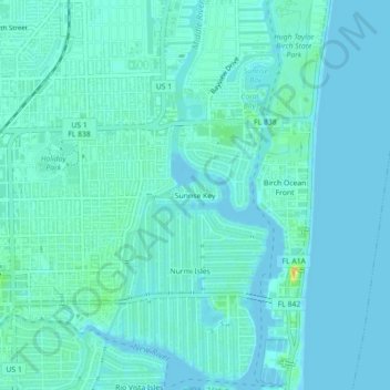
Name: Sunrise Key topographic map, elevation, terrain.
Average elevation: 16 ft
Minimum elevation: -7 ft
Maximum elevation: 108 ft
Broward County trails, hiking, mountain biking, running and outdoor activities
Other topographic maps
Click on a map to view its topography, its elevation and its terrain.
South Fork New River
United States > Florida > Broward County > Fort Lauderdale
Average elevation: 23 ft
Fort Lauderdale Beach
United States > Florida > Broward County > Fort Lauderdale > Birch Ocean Front
Average elevation: 10 ft