Geolocate

Pingit topographic map

Click on the map to display elevation.

About this map

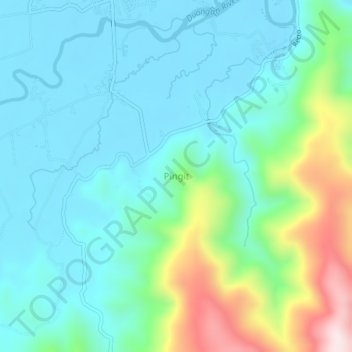
Name: Pingit topographic map, elevation, terrain.

Location: Pingit, Aurora, Central Luzon, 3200, Philippines (15.71135 121.54492 15.75135 121.58492)

Average elevation: 410 ft

Minimum elevation: 7 ft

Maximum elevation: 1,772 ft

Other topographic maps

Click on a map to view its topography, its elevation and its terrain.

Diguisit Beach

Philippines > Aurora > Baler

Average elevation: 131 ft

Casapsapan Beach

Philippines > Aurora > Casiguran

Average elevation: 72 ft

Gear up for your next adventure:

🧢Outdoor Hiking Hat - Sun protection hat for outdoor explorers
🥄Camping Utensil Set - Lightweight utensils for outdoor meals
🪶Thermal Camp Blanket - Extra warmth for cold nights
📌Outdoor GPS Map App - Apps and devices for digital topographic navigation
🪶LED Camping Lantern - Bright lantern for camp lighting

As an Amazon Associate, this site earns from qualifying purchases at no extra cost to you.