
Bougainville topographic map
Interactive map
Click on the map to display elevation.
About this map
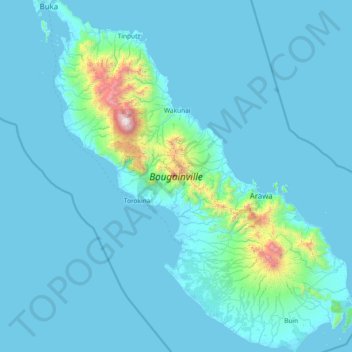
Name: Bougainville topographic map, elevation, terrain.
Average elevation: 420 ft
Minimum elevation: -3 ft
Maximum elevation: 8,848 ft
Other topographic maps
Click on a map to view its topography, its elevation and its terrain.
Lake Kathleen
Papua New Guinea > Autonomous Region of Bougainville
Lake Kathleen, Autonomous Region of Bougainville, Islands Region, Papua New Guinea
Average elevation: 276 ft
Buka
Papua New Guinea > Autonomous Region of Bougainville > Buka District
Buka, Buka District, Autonomous Region of Bougainville, Islands Region, Papua New Guinea
Average elevation: 39 ft