
Lander topographic map
Interactive map
Click on the map to display elevation.
About this map
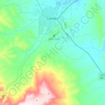
Name: Lander topographic map, elevation, terrain.
Average elevation: 5,771 ft
Minimum elevation: 5,240 ft
Maximum elevation: 7,402 ft
Other topographic maps
Click on a map to view its topography, its elevation and its terrain.
Shoshoni
Stati Uniti d'America > Wyoming > Fremont County
Shoshoni, Fremont County, Wyoming, 82649, Stati Uniti d'America
Average elevation: 4,839 ft