Geolocate

城关镇 topographic map

Interactive map

Click on the map to display elevation.

About this map

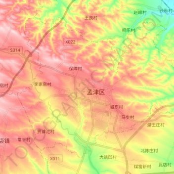
Name: 城关镇 topographic map, elevation, terrain.

Location: 城关镇, 孟津区, 洛阳市, 河南省, 471100, 中国 (34.78417 112.37640 34.87536 112.51339)

Average elevation: 988 ft

Minimum elevation: 531 ft

Maximum elevation: 1,312 ft

Other topographic maps

Click on a map to view its topography, its elevation and its terrain.

河图公园

中国 > 河南省 > 孟津区 > 城关镇

河图公园, 城关镇, 孟津区, 洛阳市, 孟津区, 河南省, 中国

Average elevation: 1,033 ft

下院沟

中国 > 河南省 > 孟津区 > 城关镇

下院沟, 城关镇, 孟津区, 洛阳市, 孟津区, 河南省, 471100, 中国

Average elevation: 1,027 ft

吉利街道

中国 > 河南省 > 孟津区

吉利街道, 孟津区, 洛阳市, 河南省, 471012, 中国

Average elevation: 446 ft

金村

中国 > 河南省 > 孟津区 > 平乐镇

金村, 平乐镇, 孟津区, 洛阳市, 河南省, 中国

Average elevation: 453 ft

马屯镇

中国 > 河南省 > 孟津区

马屯镇, 孟津区, 洛阳市, 河南省, 中国

Average elevation: 1,047 ft