Geolocate

Thomasville topographic map

Click on the map to display elevation.

About this map

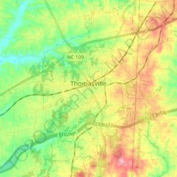
Name: Thomasville topographic map, elevation, terrain.

Location: Thomasville, Davidson County, North Carolina, 27360, United States (35.83101 -80.13742 35.92977 -80.04065)

Average elevation: 830 ft

Minimum elevation: 663 ft

Maximum elevation: 1,053 ft

Davidson County trails, hiking, mountain biking, running and outdoor activities

Other topographic maps

Click on a map to view its topography, its elevation and its terrain.

Linwood

United States > North Carolina > Davidson County

Average elevation: 679 ft

Lakeview

United States > North Carolina > Davidson County

Average elevation: 696 ft

Jersey

United States > North Carolina > Davidson County

Average elevation: 663 ft

Arnold

United States > North Carolina > Davidson County > Arnold

Average elevation: 814 ft

Gear up for your next adventure:

🧤Tactile Hiking Gloves - Keep hands warm while operating GPS and smartphone screens
🌄Hiking Binoculars - Compact binoculars for scenic views and trail spotting
🧦Hiking Socks - Comfortable socks to prevent blisters on long hikes
🛡️Insect Repellent - Protection against bugs during outdoor activities
🎒Outdoor Daypacks - Lightweight backpacks designed for carrying maps and essential gear

As an Amazon Associate, this site earns from qualifying purchases at no extra cost to you.