
Tolox topographic map
Interactive map
Click on the map to display elevation.
About this map
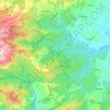
Name: Tolox topographic map, elevation, terrain.
Location: Tolox, Sierra de las Nieves, Málaga, Andalusië, 29109, Spanje (36.63482 -5.03071 36.71629 -4.84617)
Average elevation: 1,995 ft
Minimum elevation: 394 ft
Maximum elevation: 6,237 ft
Other topographic maps
Click on a map to view its topography, its elevation and its terrain.
Casarabonela
Spanje > Andalusië > Sierra de las Nieves
Casarabonela, Sierra de las Nieves, Málaga, Andalusië, 29566, Spanje
Average elevation: 1,834 ft