Geolocate

North Fork topographic map

Click on the map to display elevation.

About this map

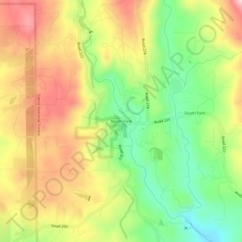
Name: North Fork topographic map, elevation, terrain.

Location: North Fork, Madera County, California, 93643, United States (37.20957 -119.52961 37.24957 -119.48961)

Average elevation: 2,858 ft

Minimum elevation: 2,388 ft

Maximum elevation: 3,333 ft

Madera County trails, hiking, mountain biking, running and outdoor activities

Other topographic maps

Click on a map to view its topography, its elevation and its terrain.

Millerton Lake

United States > California > Madera County

Average elevation: 791 ft

Chowchilla

United States > California > Madera County

Average elevation: 240 ft

Hensley Lake

United States > California > Madera County

Average elevation: 640 ft

Bass Lake

United States > California > Madera County > Bass Lake

Average elevation: 3,783 ft

Ediza Lake

United States > California > Madera County

Average elevation: 9,938 ft

Chowchilla

United States > California > Madera County

Chowchilla is a city in Madera County, California, United States. The city's population was 19,039 at the 2020 census. Chowchilla is located 16 miles (26 km) northwest of Madera, at an elevation of 240 feet (73 m).

Average elevation: 230 ft

Gear up for your next adventure:

🌄Hiking Binoculars - Compact binoculars for scenic views and trail spotting
🧭Map Reading Tools - Tools and kits for map navigation
🔭Stargazing Telescopes - Perfect for camping in low-light pollution areas shown on maps
🪶Thermal Camp Blanket - Extra warmth for cold nights
🕶️GPS Smartphone Mount - Secure mount for phone navigation

As an Amazon Associate, this site earns from qualifying purchases at no extra cost to you.