
Longford (Anna's Hope Village) topographic map
Interactive map
Click on the map to display elevation.
About this map
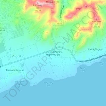
Name: Longford (Anna's Hope Village) topographic map, elevation, terrain.
Average elevation: 161 ft
Minimum elevation: 0 ft
Maximum elevation: 807 ft
Other topographic maps
Click on a map to view its topography, its elevation and its terrain.
Saint Croix
United States > United States Virgin Islands > Saint Croix District > Christiansted
Saint Croix, Christiansted, Saint Croix District, United States Virgin Islands, United States
Average elevation: 36 ft
Cartlon South
United States > United States Virgin Islands > Saint Croix District > Cartlon South
Cartlon South, Saint Croix District, United States Virgin Islands, 00840, United States
Average elevation: 75 ft
Morningstar
United States > United States Virgin Islands > Saint Croix District > Morningstar
Morningstar, Saint Croix District, United States Virgin Islands, 00820, United States
Average elevation: 223 ft
Virgin Islands
United States > United States Virgin Islands > Saint Croix District
Virgin Islands, Saint Croix District, United States Virgin Islands, United States
Average elevation: 7 ft
Frederiksted
United States > United States Virgin Islands > Saint Croix District
Frederiksted, Saint Croix District, United States Virgin Islands, 00870, United States
Average elevation: 46 ft