Geolocate

Dutton Park topographic map

Click on the map to display elevation.

About this map

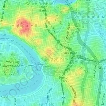
Name: Dutton Park topographic map, elevation, terrain.

Location: Dutton Park, Brisbane City, Queensland, Australia (-27.50076 153.01887 -27.48856 153.03475)

Average elevation: 72 ft

Minimum elevation: 7 ft

Maximum elevation: 200 ft

Other topographic maps

Click on a map to view its topography, its elevation and its terrain.

Willmington Park

Australia > Queensland > Brisbane City

Average elevation: 121 ft

Mount Gravatt

Australia > Queensland > Brisbane City

Average elevation: 230 ft

Ithaca

Australia > Queensland > Brisbane City > Ithaca

Average elevation: 102 ft

Gear up for your next adventure:

🪶Compact Camp Shovel - Folding shovel for campsite tasks
📦Dry Bags Set - Waterproof storage for electronics and clothes
🔥Camping Stove - Portable stove for camping and backcountry cooking
Backpacking Tent - Lightweight and durable tent for multi‑day hikes
🧭Compass with Lanyard - Easy‑carry compass for navigation

As an Amazon Associate, this site earns from qualifying purchases at no extra cost to you.