
Milford Haven topographic map
Interactive map
Click on the map to display elevation.
About this map
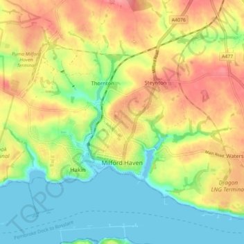
Name: Milford Haven topographic map, elevation, terrain.
Location: Milford Haven, Pembrokeshire, Wales, United Kingdom (51.69943 -5.07814 51.74201 -4.99073)
Average elevation: 118 ft
Minimum elevation: 0 ft
Maximum elevation: 253 ft
One of the earliest notable figures from the Milford Haven area is Howell Davis, a pirate born in 1680. He was shot dead in 1719 on the Portuguese island of Príncipe. Other famous residents connected as seafarers include Isaac Davis, a former seaman who was engaged in the fur trade between the Pacific Northwest and China. He became an advisor to Kamehameha I and helped form the Kingdom of Hawaii. Milford Haven has produced, or attracted, several notable artists including Arthur Symons, poet, critic, and an art editor of The Savoy magazine, who was born in the town in 1865, and Charles Norris, topographical artist, and author of A Historical Account of Tenby, who lived in Milford Haven from 1800 to 1810. The novelist Alexander Cordell lived briefly in Milford whilst employed by the Admiralty as a quantity surveyor. Journalist John Evans Woolacott, born in Milford 1861, over the course of his career edited or assistant edited various publications including the Democrat, the Weekly Dispatch, The Economist, The Statesman, the Bombay Gazette and The Pioneer. He was elected as president of the Institute of Journalists in 1908.
Other topographic maps
Click on a map to view its topography, its elevation and its terrain.
Woodstock
United Kingdom > Wales > Pembrokeshire
Woodstock, Ambleston, Pembrokeshire, Wales, SA63 4TE, United Kingdom
Average elevation: 459 ft
Pembroke
United Kingdom > Wales > Pembrokeshire
Pembroke, Pembrokeshire, Wales, United Kingdom
Average elevation: 138 ft
Lamphey
United Kingdom > Wales > Pembrokeshire
Lamphey, Pembrokeshire, Wales, SA71 5NU, United Kingdom
Average elevation: 128 ft
Hook
United Kingdom > Wales > Pembrokeshire
Hook, Pembrokeshire, Wales, SA62 4NB, United Kingdom
Average elevation: 112 ft
Llanteg
United Kingdom > Wales > Pembrokeshire
Llanteg, Amroth, Pembrokeshire, Wales, SA67 8QP, United Kingdom
Average elevation: 449 ft
Afon Dulas
United Kingdom > Wales > Pembrokeshire
Afon Dulas, Boncath, Pembrokeshire, Wales, SA37 0EL, United Kingdom
Average elevation: 404 ft
Fishguard
United Kingdom > Wales > Pembrokeshire
Fishguard, Pembrokeshire, Wales, SA65 9AN, United Kingdom
Average elevation: 249 ft
Saundersfoot
United Kingdom > Wales > Pembrokeshire > Saundersfoot
Saundersfoot, Pembrokeshire, Wales, United Kingdom
Average elevation: 135 ft
River Brynberian
United Kingdom > Wales > Pembrokeshire
River Brynberian, Eglwyswrw, Pembrokeshire, Wales, SA41 3UE, United Kingdom
Average elevation: 400 ft
Monkton
United Kingdom > Wales > Pembrokeshire > Pembroke
Monkton, Pembroke, Pembrokeshire, Wales, SA71 4LT, United Kingdom
Average elevation: 125 ft
Haverfordwest
United Kingdom > Wales > Pembrokeshire
Haverfordwest, Pembrokeshire, Wales, United Kingdom
Average elevation: 102 ft
Llanfyrnach
United Kingdom > Wales > Pembrokeshire
Llanfyrnach, Pembrokeshire, Wales, SA35 0BZ, United Kingdom
Average elevation: 620 ft