
Estelí (Municipio) topographic map
Interactive map
Click on the map to display elevation.
About this map
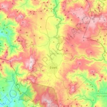
Name: Estelí (Municipio) topographic map, elevation, terrain.
Location: Estelí (Municipio), Estelí, 35000, Nicaragua (12.97287 -86.49213 13.30004 -86.16472)
Average elevation: 3,143 ft
Minimum elevation: 1,168 ft
Maximum elevation: 5,194 ft
Estelí ist eine Stadt im Norden des mittelamerikanischen Staates Nicaragua und Hauptstadt des gleichnamigen Departamentos. Sie liegt 148 km nördlich von Managua an der Panamericana im zentralen Hochland auf einer Höhe von etwa 840 m und ist von Bergen bis 1600 m umgeben. In präkolumbischer Zeit wurde die Gegend von den Chorotegas besiedelt, die die Gegend Estelí (d. h. Blutfluss) nannten. Die Stadt Estelí wurde wohl im 16. Jahrhundert von den Spaniern gegründet und ist heute ein Verwaltungs- und Wirtschaftszentrum. Bedeutung hat auch die Tabakindustrie, insbesondere die Zigarrenherstellung, sowie der Tourismus – in Estelí befinden sich zahlreiche Sprachschulen.
Other topographic maps
Click on a map to view its topography, its elevation and its terrain.