
Le Théron topographic map
Interactive map
Click on the map to display elevation.
About this map
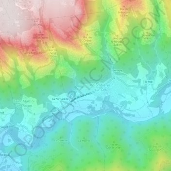
Name: Le Théron topographic map, elevation, terrain.
Average elevation: 1,440 ft
Minimum elevation: 417 ft
Maximum elevation: 3,488 ft
Other topographic maps
Click on a map to view its topography, its elevation and its terrain.
Seilhols
France > Occitania > Hérault > Colombières-sur-Orb
Seilhols, Colombières-sur-Orb, Béziers, Hérault, Occitania, Metropolitan France, 34390, France
Average elevation: 1,424 ft