
Make a donation
Gear up for your next adventure:
As an Amazon Associate, this site earns from qualifying purchases at no extra cost to you.
McClelland topographic map
Click on the map to display elevation.
Make a donation
Gear up for your next adventure:
As an Amazon Associate, this site earns from qualifying purchases at no extra cost to you.
About this map
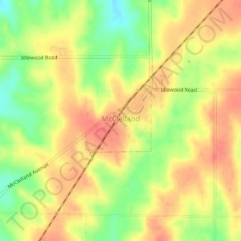
Name: McClelland topographic map, elevation, terrain.
Location: McClelland, Pottawattamie County, Iowa, United States (41.32567 -95.68925 41.33270 -95.67954)
Average elevation: 1,211 ft
Minimum elevation: 1,099 ft
Maximum elevation: 1,280 ft
Pottawattamie County trails, hiking, mountain biking, running and outdoor activities
Make a donation
Gear up for your next adventure:
As an Amazon Associate, this site earns from qualifying purchases at no extra cost to you.
Other topographic maps
Click on a map to view its topography, its elevation and its terrain.
Underwood
United States > Iowa > Pottawattamie County > Underwood > Underwood
Average elevation: 1,129 ft