
Thank you for supporting this site ❤️
Make a donation
Make a donation
Gear up for your next adventure:
As an Amazon Associate, this site earns from qualifying purchases at no extra cost to you.
Khewra topographic map
Click on the map to display elevation.
Thank you for supporting this site ❤️
Make a donation
Make a donation
Gear up for your next adventure:
As an Amazon Associate, this site earns from qualifying purchases at no extra cost to you.
About this map
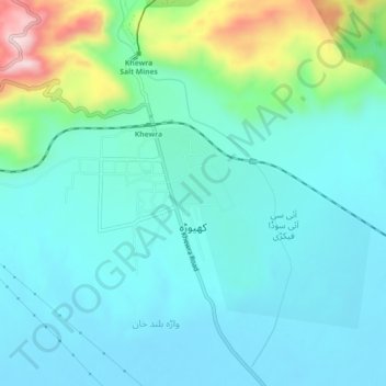
Name: Khewra topographic map, elevation, terrain.
Location: Khewra, تحصیل پنڈ دادنخان, Jhelum District, Punjab, Pakistan (32.61879 72.99312 32.64908 73.03823)
Average elevation: 889 ft
Minimum elevation: 669 ft
Maximum elevation: 1,752 ft
Thank you for supporting this site ❤️
Make a donation
Make a donation
Gear up for your next adventure:
As an Amazon Associate, this site earns from qualifying purchases at no extra cost to you.