
Vilangad topographic map
Interactive map
Click on the map to display elevation.
About this map
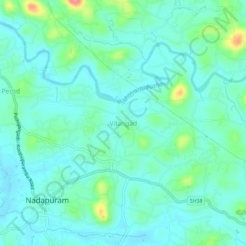
Name: Vilangad topographic map, elevation, terrain.
Location: Vilangad, Vadakara, Kozhikode district, Kerala, 673504, India (11.67768 75.64702 11.71768 75.68702)
Average elevation: 89 ft
Minimum elevation: 23 ft
Maximum elevation: 341 ft
Other topographic maps
Click on a map to view its topography, its elevation and its terrain.
Banasura Peak
Banasura Peak, Vadakara, Kozhikode District, Kerala, 670731, India
Average elevation: 4,990 ft
Villiappally
Villiappally, Vadakara, Kozhikode District, Kerala, 673542, India
Average elevation: 89 ft
Koodal
India > Kerala > Vadakara > Thottilpalam
Koodal, Thottilpalam, Vadakara, Kozhikode District, Kerala, 673513, India
Average elevation: 394 ft
Chathangottunada
India > Kerala > Vadakara > Thottilpalam
Chathangottunada, Thottilpalam, Vadakara, Kozhikode district, Kerala, 673513, India
Average elevation: 620 ft
Iringannur Maha Siva Temple chira
Iringannur Maha Siva Temple chira, Vadakara, Kozhikode district, Kerala, India
Average elevation: 49 ft
Payamkuttimala
India > Kerala > Vadakara > Mandarathur
Payamkuttimala, Mandarathur, Vadakara, Kozhikode district, Kerala, India
Average elevation: 85 ft
Mandarathur
Mandarathur, Vadakara, Kozhikode District, Kerala, 673105, India
Average elevation: 69 ft