
The Municipal District of Borris-in-Ossory — Mountmellick topographic map
Interactive map
Click on the map to display elevation.
About this map
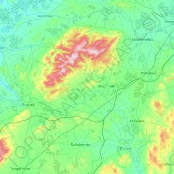
Name: The Municipal District of Borris-in-Ossory — Mountmellick topographic map, elevation, terrain.
Average elevation: 433 ft
Minimum elevation: 125 ft
Maximum elevation: 1,719 ft
Other topographic maps
Click on a map to view its topography, its elevation and its terrain.
Spink
Spink, The Municipal District of Portlaoise, County Laois, Leinster, Ireland
Average elevation: 719 ft
Hewson Hill
Hewson Hill, The Municipal District of Portlaoise, County Laois, Leinster, R32 EY73, Ireland
Average elevation: 499 ft
Cross
Cross, Kildellig ED, The Municipal District of Borris-in-Ossory — Mountmellick, County Laois, Leinster, Ireland
Average elevation: 351 ft
Lea
Lea, Kilmullen ED, The Municipal District of Graiguecullen — Portarlington, County Laois, Leinster, Ireland
Average elevation: 233 ft
Portlaoise
Ireland > County Laois > Portlaoise
Portlaoise, The Municipal District of Portlaoise, County Laois, Leinster, R32 DX07, Ireland
Average elevation: 351 ft
Ballacolla
Ireland > County Laois > Ballacolla
Ballacolla, The Municipal District of Borris-in-Ossory — Mountmellick, County Laois, Leinster, Ireland
Average elevation: 295 ft