
Malaspina Glacier topographic map
Interactive map
Click on the map to display elevation.
About this map
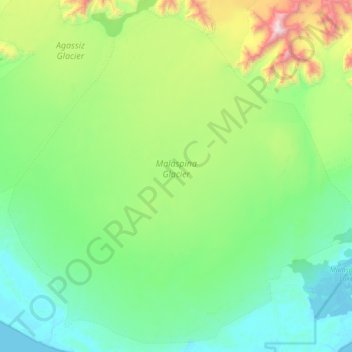
Name: Malaspina Glacier topographic map, elevation, terrain.
Location: Malaspina Glacier, Yakutat, Alaska, United States (59.74222 -140.95854 60.13048 -140.14049)
Average elevation: 1,289 ft
Minimum elevation: -10 ft
Maximum elevation: 6,844 ft
The Malaspina is up to 600 meters (2,000 ft) thick in places, with the elevation of its bottom being estimated to be as much as 300 m (980 ft) below sea level.[4] There are two lakes on its margins: Oily Lake to the northwest, at the foot of the Samovar Hills between the Agassiz and Seward glaciers, and Malaspina Lake to the southeast, close to Yakutat Bay.
Other topographic maps
Click on a map to view its topography, its elevation and its terrain.
Mount Saint Elias
United States > Alaska > Yakutat
Mount Saint Elias, Yakutat, Alaska, United States
Average elevation: 15,328 ft