
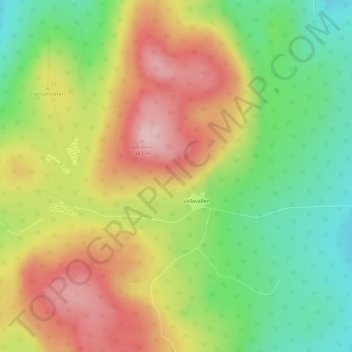
Vallåsen topographic map
Interactive map
Click on the map to display elevation.
About this map
Name: Vallåsen topographic map, elevation, terrain.
Average elevation: 741 ft
Minimum elevation: 397 ft
Maximum elevation: 1,122 ft
Other topographic maps
Click on a map to view its topography, its elevation and its terrain.
Järvsö
Sweden > Gävleborg County > Järvsö
Järvsö, Ljusdals kommun, Gävleborg County, Region Norrland, 820 40, Sweden
Average elevation: 591 ft
Hudiksvall
Sweden > Gävleborg County > Hudiksvall
Hudiksvall, Hudiksvalls kommun, Gävleborg County, Region Norrland, 82423, Sweden
Average elevation: 108 ft
Gävle
Sweden > Gävleborg County > Gävle
Gävle, Gävle kommun, Gävleborg County, Region Norrland, 80130, Sweden
Average elevation: 128 ft
Kölen
Kölen, Ljusdal, Province Hälsingland, Gävleborg County, Region Norrland, Sweden
Average elevation: 1,010 ft
Ljusdal
Sweden > Gävleborg County > Ljusdal
Ljusdal, Province Hälsingland, Gävleborg County, Region Norrland, 82700, Sweden
Average elevation: 525 ft
Limön
Sweden > Gävleborg County > Gävle
Limön, Gävle, Province Gästrikland, Gävleborg County, Region Norrland, Sweden
Average elevation: 3 ft
Garpkölen
Garpkölen, Ljusdal, Province Hälsingland, Gävleborg County, Region Norrland, Sweden
Average elevation: 1,598 ft
Söderåsen
Sweden > Gävleborg County > Söderåsen
Söderåsen, Nordanstig, Province Hälsingland, Gävleborg County, Region Norrland, Sweden
Average elevation: 407 ft
Hudiksvall
Hudiksvall, Province Hälsingland, Gävleborg County, Region Norrland, Sweden
Average elevation: 322 ft