
Schœlcher topographic map
Interactive map
Click on the map to display elevation.
About this map
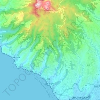
Name: Schœlcher topographic map, elevation, terrain.
Location: Schœlcher, Fort-de-France, Martinique, 97233, France (14.60013 -61.11902 14.70345 -61.08124)
Average elevation: 778 ft
Minimum elevation: 0 ft
Maximum elevation: 3,819 ft
Other topographic maps
Click on a map to view its topography, its elevation and its terrain.
L'Enclos
France > Martinique > Schœlcher > L'Enclos
L'Enclos, Schœlcher, Fort-de-France, Martinique, 97233, France
Average elevation: 197 ft