
Make a donation
Gear up for your next adventure:
As an Amazon Associate, this site earns from qualifying purchases at no extra cost to you.
Ioannina topographic map
Click on the map to display elevation.
Make a donation
Gear up for your next adventure:
As an Amazon Associate, this site earns from qualifying purchases at no extra cost to you.
Ioannina
According to the 2021 census, the city population was 64,896 while the municipality had 113,978 inhabitants. It lies at an elevation of approximately 500 metres (1,640 feet) above sea level, on the western shore of Lake Pamvotis (Παμβώτις). Ioannina is located 410 km (255 mi) northwest of Athens, 260 kilometres (162 miles) southwest of Thessaloniki and 80 km (50 miles) east of the port of Igoumenitsa on the Ionian Sea.
Make a donation
Gear up for your next adventure:
As an Amazon Associate, this site earns from qualifying purchases at no extra cost to you.
About this map
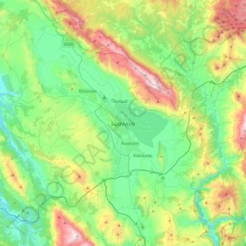
Name: Ioannina topographic map, elevation, terrain.
Average elevation: 2,375 ft
Minimum elevation: 886 ft
Maximum elevation: 5,919 ft
Make a donation
Gear up for your next adventure:
As an Amazon Associate, this site earns from qualifying purchases at no extra cost to you.
Other topographic maps
Click on a map to view its topography, its elevation and its terrain.
Vikos–Aoos National Park
Greece > Epirus > Ioannina Regional Unit
The Vikos–Aoös National Park (Greek: Εθνικός Δρυμός Βίκου–Αώου, romanized: Ethnikós Drymós Víkou–Aóou) is a national park in the region of Epirus in northwestern Greece. The park, founded in 1973, is one of ten national parks in mainland Greece and is located 30 kilometres (19…
Average elevation: 3,763 ft