
Make a donation
Gear up for your next adventure:
As an Amazon Associate, this site earns from qualifying purchases at no extra cost to you.
Holland topographic map
Click on the map to display elevation.
Make a donation
Gear up for your next adventure:
As an Amazon Associate, this site earns from qualifying purchases at no extra cost to you.
Holland
Holland is located in the southeast corner of Hampden County in western Massachusetts. It is drained by the Quinebaug River and contains the Hamilton Reservoir, one of the largest reservoirs in southern New England. The town is nestled amongst two hill ranges, where elevations reach up to greater than 1,100 feet (340 m), for example on Rattlesnake Mountain in the northwest part of town.
Make a donation
Gear up for your next adventure:
As an Amazon Associate, this site earns from qualifying purchases at no extra cost to you.
About this map
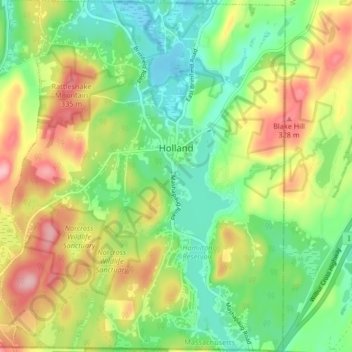
Name: Holland topographic map, elevation, terrain.
Location: Holland, Hampden County, Massachusetts, 01521, United States (42.03022 -72.20175 42.09154 -72.13511)
Average elevation: 843 ft
Minimum elevation: 627 ft
Maximum elevation: 1,158 ft
Hampden County trails, hiking, mountain biking, running and outdoor activities
Make a donation
Gear up for your next adventure:
As an Amazon Associate, this site earns from qualifying purchases at no extra cost to you.
Other topographic maps
Click on a map to view its topography, its elevation and its terrain.
Mittineague
United States > Massachusetts > Hampden County > West Springfield
Average elevation: 161 ft
Make a donation
Gear up for your next adventure:
As an Amazon Associate, this site earns from qualifying purchases at no extra cost to you.
Make a donation
Gear up for your next adventure:
As an Amazon Associate, this site earns from qualifying purchases at no extra cost to you.
Palmer Green Estates
United States > Massachusetts > Hampden County > Palmer
Average elevation: 459 ft
Make a donation
Gear up for your next adventure:
As an Amazon Associate, this site earns from qualifying purchases at no extra cost to you.
Victory Lake Dam
United States > Massachusetts > Hampden County > Camp Spruce Hill
Average elevation: 1,040 ft
Make a donation
Gear up for your next adventure:
As an Amazon Associate, this site earns from qualifying purchases at no extra cost to you.
Make a donation
Gear up for your next adventure:
As an Amazon Associate, this site earns from qualifying purchases at no extra cost to you.
Skyland
United States > Massachusetts > Hampden County > Tolland > Skyland
Average elevation: 1,211 ft
Make a donation
Gear up for your next adventure:
As an Amazon Associate, this site earns from qualifying purchases at no extra cost to you.