
Reserva Comunal Tuntanaín topographic map
Interactive map
Click on the map to display elevation.
About this map
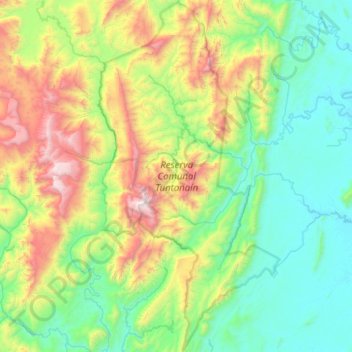
Name: Reserva Comunal Tuntanaín topographic map, elevation, terrain.
Average elevation: 2,303 ft
Minimum elevation: 554 ft
Maximum elevation: 7,188 ft
Other topographic maps
Click on a map to view its topography, its elevation and its terrain.
Pachacutec
Perú > Amazonas > Río Santiago
Pachacutec, Río Santiago, Condorcanqui, Amazonas, Perú
Average elevation: 889 ft
Esperanza
Perú > Amazonas > Río Santiago
Esperanza, Río Santiago, Condorcanqui, Amazonas, Perú
Average elevation: 636 ft