
Oxbow topographic map
Click on the map to display elevation.
About this map
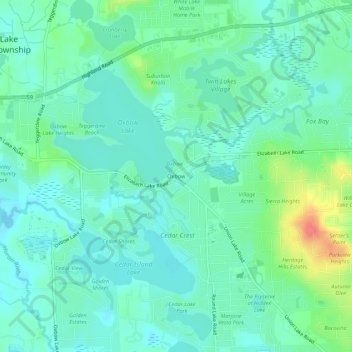
Name: Oxbow topographic map, elevation, terrain.
Average elevation: 961 ft
Minimum elevation: 909 ft
Maximum elevation: 1,109 ft
Oakland County trails, hiking, mountain biking, running and outdoor activities
Other topographic maps
Click on a map to view its topography, its elevation and its terrain.
White Lake
United States > Michigan > Oakland County > White Lake Charter Township
Average elevation: 1,030 ft
Pontiac Lake State Recreation Area
United States > Michigan > Oakland County > White Lake Charter Township
Average elevation: 1,001 ft
Cranberry Lake
United States > Michigan > Oakland County > White Lake Charter Township
Average elevation: 968 ft
White Lake
United States > Michigan > Oakland County > White Lake Charter Township
Average elevation: 1,030 ft