
Thank you for supporting this site ❤️
Make a donation
Make a donation
Gear up for your next adventure:
As an Amazon Associate, this site earns from qualifying purchases at no extra cost to you.
Warragul topographic map
Click on the map to display elevation.
Thank you for supporting this site ❤️
Make a donation
Make a donation
Gear up for your next adventure:
As an Amazon Associate, this site earns from qualifying purchases at no extra cost to you.
About this map
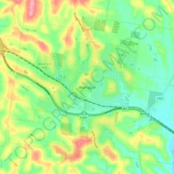
Name: Warragul topographic map, elevation, terrain.
Location: Warragul, Shire of Baw Baw, Victoria, 3820, Australia (-38.19887 145.89363 -38.11887 145.97363)
Average elevation: 436 ft
Minimum elevation: 285 ft
Maximum elevation: 682 ft
Thank you for supporting this site ❤️
Make a donation
Make a donation
Gear up for your next adventure:
As an Amazon Associate, this site earns from qualifying purchases at no extra cost to you.