
Majuli topographic map
Interactive map
Click on the map to display elevation.
About this map
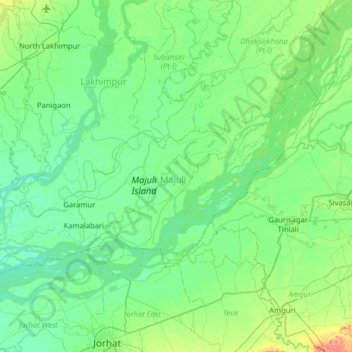
Name: Majuli topographic map, elevation, terrain.
Location: Majuli, Assam, 785104, India (26.86653 93.95991 27.18552 94.59583)
Average elevation: 295 ft
Minimum elevation: 240 ft
Maximum elevation: 554 ft
Other topographic maps
Click on a map to view its topography, its elevation and its terrain.
Nambor-Doigrung WLS
Nambor-Doigrung WLS, Morangi, Golaghat District, Assam, 785613, India
Average elevation: 367 ft